Toast your Inbox.
Join the mailing list for notification of new features.
The Industries
The Lawsuits
Asbestos Mineral location
Many areas in the United States are known to have, had previously, or been prospected for Asbestos. It is common for Asbestos to be found as part of other mining operations. The following data helps show where you are likely to be exposed to natural deposits of asbestos. Several Maps are available. Below are detailed locations to avoid in your area, just observe the GPS coordinates.Asbestos Mineral Map
Maps: Map 1 Map 2 Map 3 Map 4 Map 5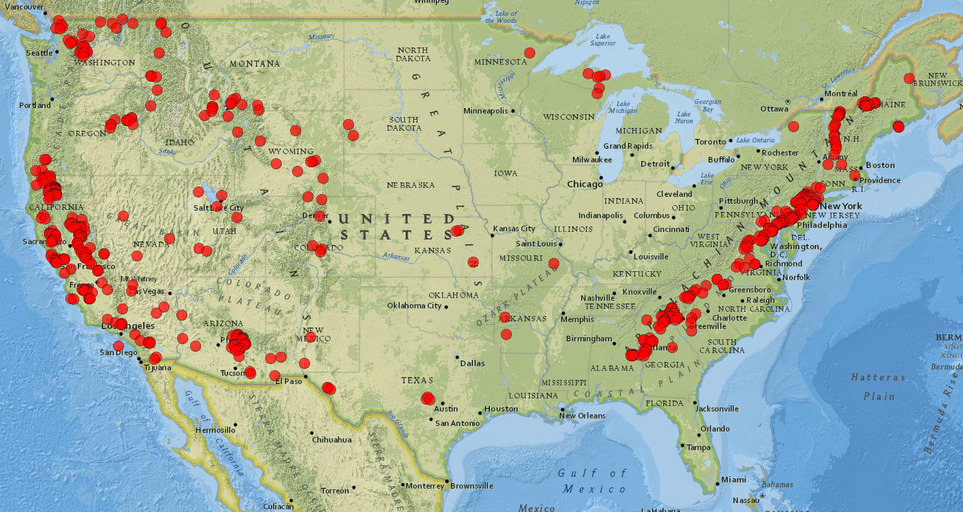
Asbestos Mineral Locations
This Table lists the details of the Asbestos sites shown on the map above in the following States:AL, AR, AZ, CA, CO, CT, DE, GA, ID, KS, MA, MD, ME, MI, MN, MO, MT, NC, NJ, NM, NV, NY, OR, PA, RI, SC, SD, TX, UT, VA, VT, WA, WI, WY
| State | Name | Type | Lat | Lon | |||
| AL | Camp Hill Road properties | occurrence | 32.867 | -85.618 | |||
| AL | Perry Wise-Sanders property | past prospect | 32.887 | -85.757 | |||
| AL | W.B. Railey property | occurrence | 32.899 | -85.736 | |||
| AL | Sorrell Estate property | past prospect | 32.912 | -85.697 | |||
| AL | Fargarson property | occurrence | 32.92 | -85.686 | |||
| AL | Clem Vines property, south area | past prospect | 32.922 | -85.615 | |||
| AL | Clarence Ware property | occurrence | 32.922 | -85.604 | |||
| AL | Garfield Heard property | past prospect | 32.923 | -85.622 | |||
| AL | George Sims property | past prospect | 32.924 | -85.618 | |||
| AL | Pettus Harris property | past prospect | 32.925 | -85.6 | |||
| AL | Prather property | past prospect | 32.926 | -85.649 | |||
| AL | Clema Smith property | occurrence | 32.926 | -85.643 | |||
| AL | Clem Vines property, north area | past prospect | 32.928 | -85.615 | |||
| AL | Knight property | occurrence | 32.929 | -85.668 | |||
| AL | Walker property | past prospect | 32.933 | -85.659 | |||
| AL | unnamed occurrence | occurrence | 32.936 | -85.579 | |||
| AL | Estes property | occurrence | 32.938 | -85.634 | |||
| AL | Coosa River News Print property | past prospect | 32.94 | -85.623 | |||
| AL | Jennings-Satterwhite properties | occurrence | 32.94 | -85.602 | |||
| AR | Prairie Creek lamproite | occurrence | 34.0336 | -93.6756 | |||
| AR | unnamed peridotite dikes | occurrence | 34.9373 | -93.7603 | |||
| AZ | Bass deposits | past producer | 36.2519 | -112.3792 | |||
| AZ | Hance deposits | past producer | 36.048 | -111.9425 | |||
| AZ | Big Jim vein | occurrence | 35.0235 | -114.3798 | |||
| AZ | American Asbestos Cement Corp. No. 2 mine (Triangle Asbestos Co. group) | past producer | 34.0242 | -110.8479 | |||
| AZ | American Asbestos Cement Corp. No. 1 mine (Triangle Asbestos Co. group) | past producer | 34.0231 | -110.838 | |||
| AZ | Home mine | past producer | 34.0211 | -110.832 | |||
| AZ | Tony mine | past producer | 34.0094 | -110.8366 | |||
| AZ | Wolf Springs prospect | past prospect | 34.0073 | -110.8514 | |||
| AZ | No. 7 prospect | past prospect | 34.0058 | -110.8421 | |||
| AZ | Sloan Creek group (Aileen group) | past producer | 34.0039 | -110.7988 | |||
| AZ | Man O'War mine | past producer | 34.001 | -110.875 | |||
| AZ | Buckhorn mine | past producer | 34.0006 | -110.8567 | |||
| AZ | Hardluck claim of the Melrose mines | past producer | 33.992 | -110.885 | |||
| AZ | Maxwell claims of the Melrose mines | past producer | 33.99 | -110.875 | |||
| AZ | White Beauty claims of the Melrose mines | past producer | 33.9889 | -110.8955 | |||
| AZ | P-38 claims of the Melrose mines | past producer | 33.987 | -110.888 | |||
| AZ | J.W. workings of the Melrose mines | past producer | 33.9865 | -110.8778 | |||
| AZ | Bore Tree Saddle Asbestos Co. property | past prospect | 33.977 | -110.9299 | |||
| AZ | American Fiber Co. properties (Rock House Group)--North deposits | past producer | 33.9583 | -110.7923 | |||
| AZ | Double Buttes prospect | past prospect | 33.94 | -110.7543 | |||
| AZ | Independent group | past prospect | 33.94 | -111.1553 | |||
| AZ | White Hill properties | past prospect | 33.9391 | -110.7694 | |||
| AZ | American Fiber Co. properties (Rock House Group)--South deposit (May mine) | past producer | 33.935 | -110.802 | |||
| AZ | Montezuma No. 3 prospect | past prospect | 33.9337 | -110.8057 | |||
| AZ | Rosa claims | past producer | 33.867 | -110.936 | |||
| AZ | Metate No. 1 prospect | past prospect | 33.8604 | -110.9017 | |||
| AZ | Lucky Strike group (Sloane group) | past producer | 33.8546 | -110.8987 | |||
| AZ | Pueblo group | past producer | 33.8526 | -110.9005 | |||
| AZ | Loey and Lena property | past producer | 33.852 | -110.558 | |||
| AZ | Apache mine (Crown Asbestos Mines, Inc. property; Seven Star group) | past producer | 33.8511 | -110.5774 | |||
| AZ | Apache Extension group | past prospect | 33.851 | -110.572 | |||
| AZ | Reynolds Falls group | past producer | 33.845 | -110.9272 | |||
| AZ | Fiber King mine (Riverside group) | past producer | 33.8348 | -110.5946 | |||
| AZ | Punto Negro group | past prospect | 33.824 | -110.557 | |||
| AZ | Cibecue Mining Co. (Old Prochnow) property | past prospect | 33.819 | -110.464 | |||
| AZ | Salt River group | past producer | 33.8175 | -110.5377 | |||
| AZ | Regal group | past producer | 33.8175 | -110.5954 | |||
| AZ | occurrences in the northern Dome Rock Mountains | occurrence | 33.813 | -114.354 | |||
| AZ | White Tail group (Enders mine) | past producer | 33.8128 | -110.5088 | |||
| AZ | Cliffbestos group | past prospect | 33.8123 | -110.6013 | |||
| AZ | River group (Crosthwaite-Steward group) | past prospect | 33.8119 | -110.5629 | |||
| AZ | Oso claim | occurrence | 33.808 | -110.536 | |||
| AZ | Canadian mine (Asbestos King claims) | past producer | 33.8067 | -110.5417 | |||
| AZ | Stansbury deposit (K & M mine; Arizona Asbestos Mining Co. property) | past producer | 33.8032 | -110.3743 | |||
| AZ | Fourth of July prospect | past producer | 33.8025 | -110.6113 | |||
| AZ | Dream Girl prospect | past producer | 33.802 | -110.525 | |||
| AZ | Snake Hill deposit (Bluff claims) | past producer | 33.7989 | -110.4936 | |||
| AZ | Wonder and Silk claims | past prospect | 33.798 | -110.4713 | |||
| AZ | Sorsen-Williams Asbestos Corp. properties | past producer | 33.7935 | -110.4932 | |||
| AZ | Great View claims (Cobb & Dunaway group) | past producer | 33.7925 | -110.5023 | |||
| AZ | Golden Fiber Asbestos Claims 1 & 2 (Old Falls group) | past prospect | 33.7858 | -110.5147 | |||
| AZ | unnamed prospect | past prospect | 33.7855 | -110.4794 | |||
| AZ | Pine Top group | past producer | 33.7844 | -110.5079 | |||
| AZ | Seventy-two and Monte Christo groups (Grandview No. 4 mine) | past producer | 33.7844 | -110.5305 | |||
| AZ | Wonder group | past prospect | 33.784 | -110.602 | |||
| AZ | Emsco mine (Accident group) | past producer | 33.7808 | -110.5247 | |||
| AZ | Falls group | past prospect | 33.78 | -110.516 | |||
| AZ | Alamo prospects | past prospect | 33.768 | -110.576 | |||
| AZ | asbestos prospects northeast of Seneca | past prospect | 33.762 | -110.493 | |||
| AZ | American Ores mine | past producer | 33.7616 | -110.9468 | |||
| AZ | Sulphur Springs claims | past prospect | 33.758 | -110.484 | |||
| AZ | Loafer claim (Old Knighton property) | past prospect | 33.7565 | -110.9328 | |||
| AZ | Ruiz prospects | past producer | 33.7444 | -110.6093 | |||
| AZ | Globe group (Friday claim) | past producer | 33.7437 | -110.9435 | |||
| AZ | Little Favor group | past prospect | 33.7409 | -110.5837 | |||
| AZ | Arizona Asbestos Assocation Group (Victory mine) | past producer | 33.739 | -110.5646 | |||
| AZ | Globe Asbestos group (Locke mine) | past producer | 33.735 | -110.5942 | |||
| AZ | El Dorado mine | past producer | 33.7335 | -110.5648 | |||
| AZ | Miami group | past producer | 33.7298 | -110.9356 | |||
| AZ | Triple Star Mining Co. property | past producer | 33.7248 | -110.5735 | |||
| AZ | unnamed prospect along Bear Creek | past prospect | 33.553 | -110.325 | |||
| AZ | unnamed prospect along Bear Creek | past prospect | 33.5469 | -110.3285 | |||
| AZ | unnamed prospect along Bear Creek | past prospect | 33.5436 | -110.3281 | |||
| AZ | G and H No. 1 prospect | past prospect | 33.543 | -110.892 | |||
| AZ | unnamed prospect along Bear Creek | past prospect | 33.542 | -110.337 | |||
| AZ | Bear Canyon Mining Co. properties | past producer | 33.5352 | -110.3333 | |||
| AZ | prospect west of Blue River | past prospect | 33.52 | -110.285 | |||
| AZ | Black Mesa (Cassadore) deposit | past prospect | 33.485 | -110.398 | |||
| AZ | Chuckwalla claims | past prospect | 33.476 | -110.91 | |||
| AZ | unnamed prospects | past prospect | 33.464 | -110.907 | |||
| AZ | North American Asbestos Co. claims | past prospect | 33.46 | -111.067 | |||
| AZ | occurrences near Pinto Creek | occurrence | 33.4547 | -111.0212 | |||
| AZ | G and H No. 2 prospects | past prospect | 33.4502 | -110.7037 | |||
| AZ | Chromo Butte prospect | past prospect | 33.45 | -110.7032 | |||
| AZ | Independence group | past prospect | 33.4415 | -111.0573 | |||
| AZ | Last Time group | past prospect | 33.4313 | -111.064 | |||
| AZ | Mountain of Mystery group | past prospect | 33.4284 | -111.0819 | |||
| AZ | K and S group | past prospect | 33.4262 | -111.0651 | |||
| AZ | asbestos occurrence on Oak Creek | occurrence | 33.422 | -110.417 | |||
| AZ | Metate Asbestos Corp. claims (Apache mine) | past producer | 33.4117 | -110.6054 | |||
| AZ | prospects on Cemetery Ridge | past prospect | 33.3853 | -113.4895 | |||
| AZ | Lucky Lager claims | past prospect | 33.322 | -111.23 | |||
| AZ | Lone Pine prospects | past prospect | 33.289 | -110.736 | |||
| AZ | Indian Springs deposit | past prospect | 33.2876 | -110.7322 | |||
| AZ | Chiricahua group | past prospect | 33.263 | -110.633 | |||
| AZ | Mystery prospect | past prospect | 33.262 | -110.647 | |||
| AZ | prospect north of Red Whiskers Spring | past prospect | 33.244 | -110.634 | |||
| AZ | unnamed prospects | past prospect | 33.198 | -110.804 | |||
| AZ | Mescal Mountain deposit | past prospect | 33.191 | -110.805 | |||
| AZ | Ray-Kelvin silver-lead mine | occurrence | 33.1778 | -110.9475 | |||
| AZ | Putnam Wash deposits | past prospect | 32.8378 | -110.731 | |||
| AZ | occurrence near the Empire No. 2 shaft | occurrence | 32.0222 | -110.0598 | |||
| AZ | Abril zinc mine | occurrence | 31.9083 | -109.992 | |||
| AZ | Boggs mine | former gold-silver-co | 34.452 | -112.258 | |||
| AZ | Old Dominion mine | former copper mine | 33.4147 | -110.7902 | |||
| AZ | Morenci district | copper mines | 33.099 | -109.366 | |||
| AZ | occurrence on Ash Peak | outcrops | 32.752 | -109.262 | |||
| AZ | Toughnut mine | former lead-silver-zi | 31.707 | -110.0671 | |||
| CA | John D. Hoff mine | past producer | 37.804 | -122.14 | |||
| CA | George Thomas prospect | past prospect | 38.332 | -120.754 | |||
| CA | Mace Ranch prospect | past prospect | 38.3647 | -120.8926 | |||
| CA | unnamed occurrence | occurrence | 39.5 | -121.38 | |||
| CA | unnamed occurrence | occurrence | 39.63 | -121.51 | |||
| CA | unnamed occurrence | occurrence | 39.69 | -121.57 | |||
| CA | unnamed occurrence | occurrence | 39.69 | -121.35 | |||
| CA | unnamed occurrence | occurrence | 39.7 | -121.4 | |||
| CA | John Quirk mine | past producer | 39.84 | -121.59 | |||
| CA | Jefferson Lake mine (American, Calaveras, California, Copperopolis, Pacific, Voorhees) | past producer | 37.9378 | -120.546 | |||
| CA | Liberty (McFall) chromite mine | occurrence | 37.956 | -120.554 | |||
| CA | Turner and Lloyd deposit (Skipper claims?) | past prospect | 38.0258 | -120.6386 | |||
| CA | unnamed prospect | past prospect | 38.1378 | -120.5019 | |||
| CA | Nuland and Nuner prospects | past prospect | 38.21 | -120.68 | |||
| CA | unnamed occurrence | occurrence | 38.23 | -120.504 | |||
| CA | Neugebauer chromite mine | occurrence | 38.241 | -120.801 | |||
| CA | Garnet Hill occurrence | occurrence | 38.4796 | -120.2517 | |||
| CA | Spring east of Alice mine | occurrence | 39.083 | -122.443 | |||
| CA | Deadshot Spring | occurrence | 39.0864 | -122.4608 | |||
| CA | Fouts Red Eye Spring | occurrence | 39.3509 | -122.6704 | |||
| CA | Prospect in Sycamore Canyon | past prospect | 37.8818 | -121.8851 | |||
| CA | Prospect in Perkins Canyon | past prospect | 37.8878 | -121.8778 | |||
| CA | Prospects near Arroyo del Cerro | past prospect | 37.8899 | -121.9717 | |||
| CA | Prospects east of Russellman Park | past prospect | 37.9112 | -121.8991 | |||
| CA | Berkeley Hills serpentine | occurrence | 37.934 | -122.314 | |||
| CA | occurrences in the Rock Creek Butte area | occurrence | 41.531 | -123.657 | |||
| CA | roadcut near El Dorado Hills | occurrence | 38.5956 | -121.0016 | |||
| CA | Oak Ridge occurrence | occurrence | 38.6785 | -121.0733 | |||
| CA | Woedee Drive occurrence | occurrence | 38.6802 | -121.0749 | |||
| CA | Harvard Way occurrence | occurrence | 38.6827 | -121.0737 | |||
| CA | New York Creek trail | occurrence | 38.6951 | -121.0769 | |||
| CA | Fairchild Park occurrence | occurrence | 38.7027 | -121.076 | |||
| CA | El Dorado Copper Co. property (Contraband copper mine) | past producer | 38.875 | -120.811 | |||
| CA | French Hill claim | past prospect | 38.9376 | -120.9217 | |||
| CA | Arroyo Pasajero alluvial fan | occurrence | 36.208 | -120.083 | |||
| CA | Ross-Garcia claims | past prospect | 36.264 | -120.575 | |||
| CA | Butler Estate chromite mine | occurrence | 36.312 | -120.5468 | |||
| CA | Coalinga (Johns-Manville) mine | past producer | 36.3181 | -120.539 | |||
| CA | Atlas Asbestos Co. (Hidden Splendor, Todd) mine | past producer | 36.3237 | -120.5888 | |||
| CA | Asbestos Corporation prospects | past prospect | 36.3731 | -120.4141 | |||
| CA | H.H. Miner claims | occurrence | 36.71 | -119.47 | |||
| CA | Occurrence | occurrence | 36.345 | -120.565 | |||
| CA | Occurrence | occurrence | 36.356 | -120.593 | |||
| CA | Occurrence | occurrence | 36.35 | -120.58 | |||
| CA | Occurrence | occurrence | 36.331 | -120.545 | |||
| CA | Occurrence | occurrence | 36.33 | -120.56 | |||
| CA | Occurrence | occurrence | 36.35 | -120.59 | |||
| CA | Occurrence | occurrence | 36.33 | -120.58 | |||
| CA | Occurrence | occurrence | 36.33 | -120.59 | |||
| CA | Occurrence | occurrence | 36.32 | -120.58 | |||
| CA | Occurrence | occurrence | 36.32 | -120.56 | |||
| CA | Occurrence | occurrence | 36.32 | -120.55 | |||
| CA | Occurrence | occurrence | 36.3 | -120.56 | |||
| CA | Occurrence | occurrence | 36.3 | -120.58 | |||
| CA | Occurrence | occurrence | 36.3 | -120.59 | |||
| CA | Occurrence | occurrence | 36.31 | -120.61 | |||
| CA | Occurrence | occurrence | 36.31 | -120.55 | |||
| CA | Occurrence | occurrence | 36.36 | -120.42 | |||
| CA | Occurrence | occurrence | 36.38 | -120.42 | |||
| CA | Occurrence | occurrence | 36.39 | -120.44 | |||
| CA | Occurrence | occurrence | 36.36 | -120.4 | |||
| CA | Salt Spring, Salt Valley | occurrence | 39.4302 | -122.5362 | |||
| CA | Sulfur Spring, Salt Valley | occurrence | 39.4337 | -122.5392 | |||
| CA | Coyote Mountains nickel (Copper Contact Lode) prospect | occurrence | 32.7976 | -116.0187 | |||
| CA | Darwin mines | occurrence | 36.2793 | -117.5925 | |||
| CA | McIlroy property | past producer | 36.5365 | -117.9161 | |||
| CA | Indian Camp (Goldbelt Springs) prospect | past prospect | 36.615 | -117.523 | |||
| CA | Huntley Industrial Minerals, Inc. mine and Whitetop Mountain deposits | past producer | 36.7873 | -117.4153 | |||
| CA | San Emigdio asbestos deposit | past prospect | 34.82 | -119.15 | |||
| CA | Sunshine claims (Jawbone Canyon) | past prospect | 35.34 | -118.15 | |||
| CA | unnamed prospect | past prospect | 35.882 | -120.246 | |||
| CA | unnamed prospect | past prospect | 35.899 | -120.265 | |||
| CA | unnamed prospect | past prospect | 35.911 | -120.284 | |||
| CA | McKinley steam field | occurrence | 38.775 | -122.716 | |||
| CA | unnamed prospect | past prospect | 38.8351 | -122.631 | |||
| CA | Copsey and Jones prospect | past prospect | 38.8488 | -122.6635 | |||
| CA | Marylyne prospect | past prospect | 38.9256 | -122.5051 | |||
| CA | Allen Springs | occurrence | 39.1598 | -122.6635 | |||
| CA | Complexion Spring | occurrence | 39.1702 | -122.5121 | |||
| CA | asbestos prospect | past prospect | 39.1724 | -122.8347 | |||
| CA | asbestos prospect | past prospect | 39.174 | -122.8356 | |||
| CA | asbestos prospect | past prospect | 39.176 | -122.8372 | |||
| CA | asbestos prospect | past prospect | 39.1774 | -122.8381 | |||
| CA | Bartlett Springs | occurrence | 39.1797 | -122.7036 | |||
| CA | asbestos prospect | past prospect | 39.1835 | -122.8431 | |||
| CA | asbestos prospect | past prospect | 39.1846 | -122.8446 | |||
| CA | Occurrences on Santa Catalina Island | occurrence | 33.4079 | -118.4183 | |||
| CA | Fiber Queen asbestos mine | past producer | 34.342 | -118.458 | |||
| CA | Katz soapstone deposit | occurrence | 34.5301 | -118.2586 | |||
| CA | RR #4 | occurrence | 34.56 | -118.27 | |||
| CA | Amargosa #1 | occurrence | 34.595 | -118.199 | |||
| CA | Burro Canyon #1 | occurrence | 34.646 | -118.625 | |||
| CA | Baker gold mine | past prospect | 37.31 | -119.74 | |||
| CA | Savannah gold mine | past prospect | 37.3197 | -119.755 | |||
| CA | Deep Canyon claim | past prospect | 37.3208 | -119.7577 | |||
| CA | Angel Island | occurrence | 37.86 | -122.4378 | |||
| CA | Belvedere Island | occurrence | 37.8656 | -122.4628 | |||
| CA | unnamed occurrence | occurrence | 38.077 | -122.746 | |||
| CA | Massa Hill nephrite locality | occurrence | 38.1769 | -122.68 | |||
| CA | near Fort Baker | occurrence | 37.833 | -122.481 | |||
| CA | west peak of Mt. Tamalpais | occurrence | 37.924 | -122.599 | |||
| CA | Asbestos prospect and nearby occurrences along Highway 49 | past prospect | 37.6504 | -120.1529 | |||
| CA | Leech Lake Mountain area | occurrence | 39.9181 | -123.0867 | |||
| CA | jade occurrence | occurrence | 39.95 | -123.34 | |||
| CA | unnamed occurrence | occurrence | 38.1745 | -119.3379 | |||
| CA | unnamed occurrence | occurrence | 38.1817 | -119.3436 | |||
| CA | Burro Mountain prospects | past prospect | 35.8689 | -121.2896 | |||
| CA | Willow Creek prospects | past prospect | 35.894 | -121.4603 | |||
| CA | unnamed prospect | past prospect | 35.903 | -120.305 | |||
| CA | Table Mountain prospects | past prospect | 35.9044 | -120.2848 | |||
| CA | unnamed prospect | past prospect | 35.905 | -120.275 | |||
| CA | Tabor Mining Co. (Phoenix mine, Monticello mine, Kohler and Chase asbestos quarry, Napa asbestos quarry) | past producer | 38.4774 | -122.1917 | |||
| CA | Rolph Ranch (chromite) | past prospect | 39.12 | -120.98 | |||
| CA | Stark (Sierra) asbestos deposit | past producer | 39.36 | -120.814 | |||
| CA | unnamed occurrence (in Gas Canyon) | occurrence | 38.98 | -120.92 | |||
| CA | unnamed occurrence (near Forest Hill) | occurrence | 39.01 | -120.8 | |||
| CA | unnamed occurrence (in Lady's Canyon) | occurrence | 39.03 | -120.77 | |||
| CA | California Morning Star mine and vicinity (Washington Consolidated mine?) | past prospect | 39.1035 | -120.8547 | |||
| CA | unnamed prospect (Burnt Flat area) | past prospect | 39.105 | -120.933 | |||
| CA | unnamed prospect (Burnt Flat area) | past prospect | 39.099 | -120.932 | |||
| CA | Iowa Hill deposits (Dewey claim, Gary mine?) | past producer | 39.112 | -120.853 | |||
| CA | Roach Hill occurrence (Blue Wing claim?) | occurrence | 39.121 | -120.847 | |||
| CA | Morgan deposits (and Driscoll & Michelson claims, Wolf & Levy claims) | past producer | 39.18 | -120.792 | |||
| CA | Dan Sullivan prospect | past prospect | 39.23 | -120.8 | |||
| CA | Monumental Hill | occurrence | 39.29 | -120.59 | |||
| CA | Spring Garden Tunnel | occurrence | 39.88 | -120.779 | |||
| CA | Asbestos Nos. 1, 2, and 3 claims | past prospect | 39.99 | -121.14 | |||
| CA | Garnet Ridge prospect | past prospect | 39.99 | -121.367 | |||
| CA | unnamed occurrence near Toro Peak | occurrence | 33.524 | -116.399 | |||
| CA | Serpentine Hill prospects | past prospect | 33.605 | -116.433 | |||
| CA | Dunn asbestos deposit | past prospect | 33.6101 | -116.4824 | |||
| CA | Percival (Charleboix) asbestos deposit (Katherine C. mining claims) | past producer | 33.6132 | -116.4811 | |||
| CA | Perris asbestos deposit | past producer | 33.76 | -117.261 | |||
| CA | Crestmore quarry | occurrence | 34.0235 | -117.3846 | |||
| CA | Hemet magnesite mine | occurrence | 33.697 | -117.026 | |||
| CA | unnamed occurrence | occurrence | 33.58 | -116.53 | |||
| CA | Simas Asbestos property | past producer(?) | 36.335 | -120.7162 | |||
| CA | Santa Rita quarry (Union Carbide Corporation, KCAC mine) | past producer | 36.339 | -120.6141 | |||
| CA | San Benito Asbestos Company claims | past producer | 36.3702 | -120.7566 | |||
| CA | Occurrences in canyon of Clear Creek | occurrence | 36.382 | -120.716 | |||
| CA | Victor claim | occurrence | 36.358 | -120.742 | |||
| CA | The Gem mine (Benitoite mine, Benitoite Gem mine, Dallas Benitoite mine, Dallas Gem mine) | occurrence | 36.336 | -120.605 | |||
| CA | Golconda (Conda, Fleetfoot, Hicks) asbestos deposit (Fire-Proof?, Scorpion?) | past producer | 34.8231 | -117.2533 | |||
| CA | Cronese deposits | occurrence | 35.129 | -115.995 | |||
| CA | Mountain Pass rare earth elements deposit | occurrence | 35.4781 | -115.5299 | |||
| CA | Circle Group vermiculite group | occurrence | 32.6812 | -116.1636 | |||
| CA | Hunters Point area | occurrence | 37.7277 | -122.3703 | |||
| CA | Potrero Hill area | occurrence | 37.7566 | -122.3983 | |||
| CA | U.S. Mint area | occurrence | 37.7695 | -122.4257 | |||
| CA | Fort Point-Presidio area | occurrence | 37.8102 | -122.4757 | |||
| CA | New Almaden mine | occurrence | 37.179 | -121.8401 | |||
| CA | Red Mountain magnesite deposit | occurrence | 37.41 | -121.47 | |||
| CA | Blas Corporation property (Asbestos Empress) | past producer | 41.05 | -122.461 | |||
| CA | Circle (S) property (Shotgun Creek chromite mine) | occurrence | 41.058 | -122.387 | |||
| CA | unnamed occurrence (Asbestos Empress prospect?) | occurrence | 41.085 | -122.501 | |||
| CA | Stock property (Stock & Stevens) | past producer | 41.0994 | -122.4001 | |||
| CA | Anaconda prospect | past prospect | 41.1 | -122.37 | |||
| CA | Sylvester asbestos deposit | past producer | 41.1018 | -122.3949 | |||
| CA | unnamed occurrence | occurrence | 41.105 | -122.401 | |||
| CA | D.E. Miles prospect | past prospect | 41.11 | -122.39 | |||
| CA | Oriental gold mine | occurrence | 39.4605 | -120.8576 | |||
| CA | Sixteen to One gold-quartz-vein | occurrence | 39.4651 | -120.8426 | |||
| CA | Mammoth Springs mine | occurrence | 39.4835 | -120.819 | |||
| CA | Green and Farr prospects and Lloyd and Milward prospects | past prospect | 39.553 | -120.633 | |||
| CA | W.W. Casserly prospect | past prospect | 39.554 | -120.881 | |||
| CA | Cecilville Summit County Road/FH93 | occurrence | 41.2206 | -122.8969 | |||
| CA | Carter Meadow rock pit | occurrence | 41.2243 | -122.8973 | |||
| CA | Keystone asbestos claims | past prospect | 41.27 | -122.873 | |||
| CA | Calethia Group | past prospect | 41.279 | -122.423 | |||
| CA | Camp Eden rock pit | occurrence | 41.279 | -122.8742 | |||
| CA | High CCC rock pit | occurrence | 41.3 | -122.881 | |||
| CA | unnamed occurrence | occurrence | 41.302 | -122.495 | |||
| CA | Sugar Creek rock pit | occurrence | 41.3285 | -122.8633 | |||
| CA | unnamed prospect (Lucky Cowboy Claims?) | past prospect | 41.406 | -122.445 | |||
| CA | unnamed occurrence | occurrence | 41.36 | -122.49 | |||
| CA | unnamed occurrence | occurrence | 41.36 | -122.55 | |||
| CA | unnamed occurrence | occurrence | 41.37 | -122.49 | |||
| CA | unnamed occurrence | occurrence | 41.361 | -122.531 | |||
| CA | unnamed occurrence | occurrence | 41.38 | -122.439 | |||
| CA | Mount Eddy deposit (Rattaro prospect) | past prospect | 41.3825 | -122.4675 | |||
| CA | unnamed occurrence | occurrence | 41.4 | -122.51 | |||
| CA | unnamed occurrences | occurrence | 41.4 | -122.49 | |||
| CA | unnamed prospect | past prospect | 41.403 | -122.509 | |||
| CA | unnamed occurrence | occurrence | 41.42 | -122.53 | |||
| CA | Shasta View prospect (Sylvester asbestos deposit) | past producer | 41.4126 | -122.4519 | |||
| CA | unnamed occurrence | occurrence | 41.43 | -122.49 | |||
| CA | unnamed occurrence | occurrence | 41.43 | -122.5 | |||
| CA | unnamed occurrence | occurrence | 41.4174 | -122.5459 | |||
| CA | unnamed occurrence | occurrence | 41.43 | -122.52 | |||
| CA | unnamed occurrence | occurrence | 41.43 | -122.54 | |||
| CA | Chamberlain (Burns Ranch) prospect | past prospect | 41.4834 | -122.5467 | |||
| CA | South Kelsey Creek rock pit | occurrence | 41.6094 | -123.1686 | |||
| CA | C.C. Cady prospect | past prospect | 41.7351 | -122.7293 | |||
| CA | Straw Rock pit | occurrence | 41.7817 | -123.2054 | |||
| CA | Seiad rock pit | occurrence | 41.8312 | -123.2291 | |||
| CA | Thompson Creek rock pit | occurrence | 41.875 | -123.3332 | |||
| CA | Middle Creek rock pit | occurrence | 41.8985 | -123.0411 | |||
| CA | Salt Gulch source (J.J. Murray claims?) | occurrence | 41.903 | -123.1372 | |||
| CA | Upper Buckhorn Gulch rock pit | occurrence | 41.9122 | -122.802 | |||
| CA | Hungry Creek rock source | occurrence | 41.9635 | -122.7945 | |||
| CA | Crocidolite from Pine Flat (California Division of Mines and Geology specimen 19626) | occurrence | 38.74 | -122.76 | |||
| CA | Red Mountain deposit (Virginia Bruce mining claims) | past prospect | 40.062 | -123.219 | |||
| CA | unnamed occurrence | occurrence | 40.846 | -122.889 | |||
| CA | unnamed occurrence | occurrence | 40.977 | -122.846 | |||
| CA | Jones Brothers mine | past producer | 41.083 | -122.71 | |||
| CA | unnamed prospect | past prospect | 41.086 | -122.515 | |||
| CA | Shasta Lily No. 6, 7 | past prospect | 41.1 | -122.52 | |||
| CA | Asbestos King No. 9 claim | past prospect | 41.097 | -122.5222 | |||
| CA | Trinity asbestos claims | past prospect | 41.1051 | -122.4584 | |||
| CA | Shasta Lily 1 to 5 claims | past prospect | 41.11 | -122.54 | |||
| CA | unnamed occurrence | occurrence | 41.113 | -122.652 | |||
| CA | unnamed occurrence | occurrence | 41.116 | -122.56 | |||
| CA | Prospects near Altoona and Quicksilver mine | past prospect | 41.13 | -122.54 | |||
| CA | White Cloud prospect | past prospect | 41.1418 | -122.4938 | |||
| CA | Katzer | past prospect | 41.12 | -122.56 | |||
| CA | Eldenlou group | past producer | 41.143 | -122.603 | |||
| CA | unnamed occurrence | occurrence | 41.186 | -122.544 | |||
| CA | Dan Rice Asbestos Nos. 1, 4, 7, and 8 claims | past prospect | 41.26 | -122.66 | |||
| CA | unnamed occurrence | occurrence | 41.27 | -122.613 | |||
| CA | unnamed occurrence | occurrence | 41.271 | -122.582 | |||
| CA | Trinity River prospect | past prospect | 41.2727 | -122.6021 | |||
| CA | unnamed occurrence | occurrence | 41.2781 | -122.623 | |||
| CA | unnamed occurrence | occurrence | 41.296 | -122.612 | |||
| CA | unnamed occurrence | occurrence | 41.31 | -122.6 | |||
| CA | Hanggi Ranch deposit | past prospect | 36.3655 | -119.1434 | |||
| CA | Ashley property | past prospect | 37.7958 | -120.2746 | |||
| CA | Premier mine | past prospect | 37.9545 | -120.4439 | |||
| CA | Rawhide claims | past prospect | 37.965 | -120.457 | |||
| CA | California mine (Reed mercury mine) | occurrence | 38.8661 | -122.3717 | |||
| CA | unnamed occurrence | occurrence | 39.46 | -121.21 | |||
| CA | Galena Hill claim | occurrence | 39.47 | -121.05 | |||
| CA | Mount Hope gold mine | occurrence | 39.519 | -121.218 | |||
| CA | Butte County Pine and Hardwood Company property | past prospect | 39.52 | -121.21 | |||
| CA | Kingbird drift mine | occurrence | 39.55 | -121.14 | |||
| CA | unnamed occurrence | occurrence | 39.56 | -121.11 | |||
| CA | New Melones Lake spillway | occurrence | 37.946 | -120.531 | |||
| CA | occurrence on California State Highway 168, just west of Humphreys | roadcut | 36.9621 | -119.4469 | |||
| CA | Occurrence near Twin Lakes | outcrops | 37.2956 | -119.1529 | |||
| CA | Occurrence near Shadow Lake | outcrops | 37.697 | -119.125 | |||
| CA | unnamed occurrence | occurrence | 37.89 | -122.45 | |||
| CA | Laytonville quarry | rock quarry | 39.618 | -123.462 | |||
| CA | Cape San Martin | outcrops | 35.8903 | -121.461 | |||
| CA | Jade Cove | outcrops | 35.9179 | -121.4708 | |||
| CA | Eagle Mountains iron-ore district | historic iron mines | 33.875 | -115.536 | |||
| CA | Jensen quarry | rock quarry | 34.0225 | -117.4296 | |||
| CA | Mina Numero Uno claim | boulders and outcrop | 36.38 | -120.68 | |||
| CA | Cascade Canyon | outcrops | 34.212 | -117.663 | |||
| CA | Inspiration Point area | outcrops | 33.05 | -116.567 | |||
| CA | Kalkar quarry | rock quarry | 36.9812 | -122.0467 | |||
| CA | Gabbro body near Pine Flat Road | outcrops | 37.079 | -122.14 | |||
| CA | Moccasin area | outcrops | 37.84 | -120.349 | |||
| CA | Bonnie mine | 36.0163 | -116.8944 | ||||
| CA | Death Valley mine (includes Mammoth workings and Sidewinder claims) | 36.0142 | -116.9167 | ||||
| CA | Timmy deposit | 36.0062 | -116.891 | ||||
| CA | Montgomery (Panamint) mine | 35.9899 | -116.9421 | ||||
| CA | Warm Spring-Grantham mines | 35.9614 | -116.8946 | ||||
| CA | Panamint mine | 35.9509 | -116.8794 | ||||
| CA | Anvil Spring Canyon deposit | 35.9401 | -116.884 | ||||
| CA | Owlshead deposits | 35.869 | -116.7175 | ||||
| CA | Markley deposits | 35.8466 | -116.4049 | ||||
| CA | Eclipse mine | 35.8428 | -116.3789 | ||||
| CA | Comet deposit | 35.8338 | -116.3835 | ||||
| CA | Arletta deposits | 35.8284 | -116.3763 | ||||
| CA | Jim Francis (Giant) mine | 35.8189 | -116.384 | ||||
| CA | Mammoth mine | 35.8188 | -116.3941 | ||||
| CA | Donna Loy mine | 35.8071 | -116.085 | ||||
| CA | Atlas (Brown, Valley) deposits (includes the Ibex mine) | 35.806 | -116.4542 | ||||
| CA | Tough (A.C.) deposits | 35.804 | -116.2666 | ||||
| CA | Crystal Spring mine | 35.7931 | -115.9608 | ||||
| CA | Omega mine | 35.7869 | -115.9739 | ||||
| CA | Smith (Tecopa) mine | 35.7863 | -115.9951 | ||||
| CA | Vulcan (Harry Adams) mine | 35.7852 | -115.9343 | ||||
| CA | Western (Acme, Lindsay) mine | 35.7839 | -116.1263 | ||||
| CA | Amargosa mine | 35.7833 | -116.2033 | ||||
| CA | Rogers mine | 35.783 | -116.0079 | ||||
| CA | Ibex (Moorehouse) mine | 35.7805 | -116.4179 | ||||
| CA | Monarch mine | 35.7797 | -116.4082 | ||||
| CA | Excelsior deposit (Excelsior mine, Pioneer mine, and Apex workings) | 35.7786 | -115.8368 | ||||
| CA | Pleasanton mine | 35.7775 | -116.4111 | ||||
| CA | Snow White (Kingston No. 1) mine | 35.7772 | -115.8308 | ||||
| CA | Kingston (Kingston No. 8) deposit | 35.7738 | -115.9123 | ||||
| CA | Acme mine | 35.7681 | -116.1277 | ||||
| CA | Booth mine | 35.761 | -116.06 | ||||
| CA | Pongo mine | 35.7276 | -116.4251 | ||||
| CA | Superior mine | 35.7116 | -116.4055 | ||||
| CA | Johnson (Kingston) deposit | 35.7094 | -115.8578 | ||||
| CA | White Cap mine | 35.7058 | -116.4125 | ||||
| CA | Saratoga mine | 35.7015 | -116.4184 | ||||
| CA | Caliente (B.F.J.) mine | 35.6911 | -116.3617 | ||||
| CA | Rainbow mine | 35.685 | -116.3597 | ||||
| CA | Sheep Creek (Western Atlas) mine | 35.5949 | -116.3598 | ||||
| CA | Annex (Mammoth) mine | 35.5287 | -116.0987 | ||||
| CA | Berryhill (Riggs) mine | 35.5252 | -116.1012 | ||||
| CA | Ceramic mine (and Patricia deposit) | 35.5064 | -116.0276 | ||||
| CA | Number 5 workings | 35.4593 | -116.0066 | ||||
| CA | Addenda Extension mine | 35.4579 | -116.0264 | ||||
| CA | Addenda mine | 35.4573 | -116.0226 | ||||
| CA | Gould mine | 35.456 | -116.0195 | ||||
| CA | Number 2 1/2 workings | 35.4548 | -116.0114 | ||||
| CA | Number 2 shaft | 35.4547 | -116.0147 | ||||
| CA | Number 3 workings | 35.4535 | -116.016 | ||||
| CA | Yucca mine | 35.45 | -115.9207 | ||||
| CA | Number 4 workings | 35.4498 | -116.0003 | ||||
| CA | Pomona mine (Yucca Grove, Desert Talc and Clay) | 35.4238 | -115.8073 | ||||
| CA | Great Wanamingo mine (Calmasil Extension, Halloran Spring deposit) | 35.4238 | -115.8445 | ||||
| CA | Calmasil mine | 35.4182 | -115.8017 | ||||
| CO | Gem Park complex | occurrence | 38.2669 | -105.5449 | |||
| CO | Pinon Peak breccia pipes | occurrence | 38.4057 | -105.4768 | |||
| CO | Sedalia mine | occurrence | 38.5892 | -106.0203 | |||
| CO | Camp Albion mining district | occurrence | 40.0429 | -105.5939 | |||
| CO | Sloan pipe | occurrence | 40.8426 | -105.4562 | |||
| CO | Salt Creek vermiculite deposits | occurrence | 40.9836 | -106.332 | |||
| CO | Rico mining district | former Pb-Zn-Cu-Ag- | 37.6993 | -108.0167 | |||
| CO | Iron Hill carbonatite complex | outcrops | 38.2489 | -107.0504 | |||
| CO | Calumet iron mine | former iron mine | 38.6374 | -105.9475 | |||
| CO | Creswell mine | historic shallow adits | 39.6949 | -105.3665 | |||
| CO | Copper King uranium mine | former uranium mine | 40.851 | -105.495 | |||
| CT | unnamed mine | past producer | 41.8423 | -72.9834 | |||
| DE | Mount Cuba serpentine body | occurrence | 39.795 | -75.625 | |||
| GA | G.I. Bryan property | past prospect | 32.88 | -84.92 | |||
| GA | Mrs. W.M. Higginbothem property | past prospect | 32.9 | -85.16 | |||
| GA | Mrs. Leila Beasley property | past prospect | 33.08 | -84.916 | |||
| GA | Joseph L. Chambless property | past producer | 33.11 | -84.66 | |||
| GA | Thrash prospect | past producer | 33.11 | -84.64 | |||
| GA | Primrose Siding | occurrence | 33.15 | -84.74 | |||
| GA | Mrs. Mildred Camp property | past prospect | 33.21 | -84.74 | |||
| GA | J.A.R. Camp property | past prospect | 33.25 | -84.76 | |||
| GA | P.H. Hawk property | past prospect | 33.3 | -84.85 | |||
| GA | Moses W. Harris property | occurrence | 33.33 | -83.08 | |||
| GA | T.D. Longino property | past prospect | 33.62 | -84.52 | |||
| GA | Soapstone Ridge occurrences | occurrence | 33.653 | -84.337 | |||
| GA | unnamed occurrence | occurrence | 33.701 | -84.389 | |||
| GA | unnamed prospect | past prospect | 33.723 | -84.933 | |||
| GA | unnamed prospect | past prospect | 33.735 | -84.917 | |||
| GA | J.H. Cantrell's property | past prospect | 33.85 | -84.53 | |||
| GA | L.M. Arnold and E.R. Arnold properties | past producer | 33.98 | -83.58 | |||
| GA | unnamed prospect | past prospect | 34.29 | -83.86 | |||
| GA | unnamed prospect | past prospect | 34.446 | -83.962 | |||
| GA | Sall Mountain Company property | past producer | 34.639 | -83.753 | |||
| GA | Asbestos Mining and Manufacturing Co. (Hollywood) mine | past producer | 34.646 | -83.451 | |||
| GA | J.J. Holcomb property | occurrence | 34.65 | -83.66 | |||
| GA | Calhoun Mining Company property | occurrence | 34.66 | -83.715 | |||
| GA | Sall Mountain mine | past producer | 34.662 | -83.685 | |||
| GA | A.E. Berrong property | past producer | 34.702 | -83.624 | |||
| GA | G.L. Lyons property | past prospect | 34.707 | -83.624 | |||
| GA | John Martin prospects | past prospect | 34.749 | -83.631 | |||
| GA | Mack Mountain (Wykle) prospect | past prospect | 34.751 | -83.636 | |||
| GA | unnamed prospect | past prospect | 34.7517 | -83.6464 | |||
| GA | unnamed prospect | past prospect | 34.7593 | -83.5907 | |||
| GA | unnamed prospects | past prospect | 34.7693 | -83.5881 | |||
| GA | W.Z. Latch property | occurrence | 34.775 | -84.713 | |||
| GA | R.V. Taylor prospect | past prospect | 34.803 | -83.347 | |||
| GA | George Lowell prospect | past prospect | 34.822 | -83.496 | |||
| GA | H.V.M. Miller mine | past producer | 34.874 | -83.5745 | |||
| GA | Andrew Gennett property | past producer | 34.889 | -83.329 | |||
| GA | Chattooga River prospect | past producer | 34.917 | -83.187 | |||
| GA | Pig Pen Mountain locality | occurrence | 34.93 | -83.17 | |||
| GA | Nicholson estate mine | past producer | 34.939 | -83.173 | |||
| GA | Laurel Creek mine | past producer | 34.948 | -83.177 | |||
| GA | unnamed prospect | past prospect | 34.95 | -83.25 | |||
| GA | Thomas Edwards property | past prospect | 34.952 | -83.798 | |||
| GA | Reid mine | past producer | 34.955 | -83.173 | |||
| GA | A.A. Darnell property | past prospect | 34.959 | -83.311 | |||
| GA | L.D. Garland property | past producer | 34.97 | -83.46 | |||
| GA | Hicks Asbestos mine | past producer | 34.97 | -83.151 | |||
| GA | Mrs. Margaret Beavett property | past prospect | 34.979 | -83.423 | |||
| GA | McCoy mine | past producer | 34.979 | -83.419 | |||
| GA | Bell Creek mine | occurrence | 34.98 | -83.734 | |||
| GA | Dillard prospect | past producer | 34.984 | -83.415 | |||
| GA | R.H. Lamb property | past prospect | 34.99 | -83.44 | |||
| GA | Frank Kelly prospect | past prospect | 34.99 | -83.318 | |||
| ID | unnamed occurrences | occurrence | 45.213 | -116.352 | |||
| ID | Blacktail asbestos prospect | past prospect | 45.922 | -115.964 | |||
| ID | Kamiah asbestos deposits | past producer | 46.216 | -115.838 | |||
| ID | Orofino Creek anthophyllite deposits | occurrence | 46.488 | -116.027 | |||
| ID | Olson asbestos | past prospect | 46.536 | -116.315 | |||
| ID | Teakean asbestos deposits | past prospect | 46.547 | -116.354 | |||
| ID | Tamarack-Custer mine | occurrence | 47.5385 | -115.8575 | |||
| ID | Gold Hill stock | outcrops | 46.9668 | -116.7486 | |||
| KS | Silver City (Hills Pond) dome | occurrence | 37.7475 | -95.7867 | |||
| KS | Bala intrusion | occurrence | 39.3058 | -96.9156 | |||
| KS | Stockdale pipe | occurrence | 39.342 | -96.7239 | |||
| MA | Pelham asbestos quarry | past producer | 42.35 | -72.441 | |||
| MA | Hinsdale mine | past producer | 42.4787 | -73.127 | |||
| MA | New Salem serpentinite body | occurrence | 42.505 | -72.305 | |||
| MA | North Mountain dunite | occurrence | 42.5272 | -73.1667 | |||
| MD | Hunting Hill quarry | occurrence | 39.0806 | -77.2239 | |||
| MD | Muddy Branch talc prospect | occurrence | 39.088 | -77.275 | |||
| MD | unnamed occurrence | occurrence | 39.25 | -76.764 | |||
| MD | Gwynn Falls gneiss quarry | occurrence | 39.2895 | -76.6678 | |||
| MD | National Park Service quarry | occurrence | 39.29 | -76.79 | |||
| MD | Daniels quarry (Alberton deposit) | past producer | 39.317 | -76.814 | |||
| MD | Bok asbestos mine | past producer | 39.3183 | -76.7883 | |||
| MD | unnamed prospect at Powhatan | past prospect | 39.32 | -76.73 | |||
| MD | Bare Hills serpentine quarries and Bare Hills chrome mine | occurrence | 39.385 | -76.663 | |||
| MD | Springfield iron-copper mine | occurrence | 39.39 | -76.97 | |||
| MD | Mineral Hill mine | occurrence | 39.44 | -76.93 | |||
| MD | Delight quarry | occurrence | 39.44 | -76.8289 | |||
| MD | Reed chrome mine | occurrence | 39.612 | -76.456 | |||
| MD | unnamed occurrences near Mine Fields | occurrence | 39.639 | -76.36 | |||
| MD | Dublin talc quarries | occurrence | 39.651 | -76.285 | |||
| MD | unnamed occurrences near Clermont Mills | occurrence | 39.66 | -76.45 | |||
| MD | Neikirk mine | past producer | 39.697 | -76.384 | |||
| MD | Jenkins (Todd) mine | past producer | 39.699 | -76.377 | |||
| MD | Bald Friar quarries | occurrence | 39.699 | -76.207 | |||
| MD | Conowingo Marble and Mineral Company serpentine quarry | occurrence | 39.709 | -76.187 | |||
| MD | Weiant (Wiant) serpentine quarry | occurrence | 39.71 | -76.191 | |||
| MD | Cardiff serpentine quarry | occurrence | 39.72 | -76.34 | |||
| ME | Deer Isle serpentine | occurrence | 44.259 | -68.636 | |||
| ME | Traprock quarry | occurrence | 44.2854 | -68.7026 | |||
| ME | Little Deer Isle serpentine body | occurrence | 44.293 | -68.706 | |||
| ME | serpentine body | occurrence | 45.2232 | -70.7397 | |||
| ME | Alder Stream area serpentine | occurrence | 45.2275 | -70.6606 | |||
| ME | Tea Pond area serpentine | occurrence | 45.23 | -70.5303 | |||
| ME | serpentinite outcrop | occurrence | 45.2302 | -70.8121 | |||
| ME | serpentinite outcrop | occurrence | 45.2317 | -70.7909 | |||
| ME | serpentinite outcrop at top of 2,720-foot knob | occurrence | 45.2357 | -70.7677 | |||
| ME | serpentinite outcrop | occurrence | 45.2385 | -70.8313 | |||
| ME | Little Tea Pond area serpentine | occurrence | 45.2393 | -70.5399 | |||
| ME | Greenbush Mountain area serpentine | occurrence | 45.2393 | -70.5308 | |||
| ME | Little Spencer Stream serpentine | past prospect | 45.3256 | -70.259 | |||
| ME | Stony Brook Mountain serpentine | occurrence | 45.3276 | -70.1844 | |||
| ME | serpentine body | occurrence | 45.335 | -70.993 | |||
| ME | Eagle Pond serpentine | occurrence | 45.345 | -70.22 | |||
| ME | Lower Enchanted Pond serpentine | occurrence | 45.356 | -70.128 | |||
| ME | serpentinite body | occurrence | 45.3678 | -70.7874 | |||
| ME | serpentinite body | occurrence | 45.3764 | -70.7904 | |||
| ME | serpentinite body | occurrence | 45.3904 | -70.7944 | |||
| ME | serpentinite body | occurrence | 45.4027 | -70.7843 | |||
| ME | Porcupine Hill serpentinite | occurrence | 46.4435 | -67.996 | |||
| MI | Metronite quarry | occurrence | 46.0032 | -87.7746 | |||
| MI | Washington iron mine | occurrence | 46.4927 | -87.8805 | |||
| MI | Verde Antique quarry and Ropes gold mine property | occurrence | 46.5252 | -87.7246 | |||
| MI | Presque Isle | occurrence | 46.5904 | -87.3772 | |||
| MI | Taylor mine | occurrence | 46.6637 | -88.4416 | |||
| MI | occurrences in metagabbro sills | outcrops | 45.775 | -88 | |||
| MI | Empire iron mine | iron mine | 46.4583 | -87.6 | |||
| MI | actinolitic slates and schists | outcrops | 46.5066 | -87.3906 | |||
| MI | Centennial mine | former copper mine | 47.2558 | -88.422 | |||
| MN | occurrence in the Aurora sill | occurrence | 47.5513 | -92.1917 | |||
| MN | Eastern Mesabi district | taconite deposits | 47.667 | -91.917 | |||
| MO | unnamed prospect | former prospect | 37.625 | -90.802 | |||
| MO | Iron Mountain mine | occurrence | 37.7006 | -90.6406 | |||
| MO | Thorny Mountain mine | former manganese m | 37.1032 | -91.186 | |||
| MO | Ketcherside Gap deposit | small former copper | 37.5132 | -90.66 | |||
| MT | Little Mile Creek (Cliff Lake) asbestos deposit | past prospect | 44.7559 | -111.4252 | |||
| MT | Anderson deposit | past prospect | 44.7841 | -112.9526 | |||
| MT | Jake Creek ultramafic body | occurrence | 44.9589 | -112.5167 | |||
| MT | Red Lodge chromite district | occurrence | 45.0386 | -109.4497 | |||
| MT | Wolf Creek ultramafic pluton | occurrence | 45.075 | -112.427 | |||
| MT | unnamed occurrences | occurrence | 45.1867 | -112.4167 | |||
| MT | unnamed occurrences | occurrence | 45.1928 | -112.4425 | |||
| MT | Rosebud asbestos claim | past prospect | 45.255 | -109.554 | |||
| MT | Copper Queen claim | occurrence | 45.2876 | -110.5833 | |||
| MT | Moon Lake asbestos | past prospect | 45.319 | -111.278 | |||
| MT | Table Mountain prospect | past prospect | 45.3317 | -111.2523 | |||
| MT | Karst asbestos mine | past producer | 45.3561 | -111.1825 | |||
| MT | Wilson Creek asbestos | occurrence | 45.483 | -111.146 | |||
| MT | unnamed asbestos prospect | past prospect | 45.5668 | -110.9696 | |||
| MT | Hudson Group | occurrence | 45.694 | -112.3105 | |||
| MT | Rainy Creek complex | occurrence | 48.4348 | -115.4081 | |||
| MT | Larue-Cripe asbestos | occurrence | 48.773 | -115.696 | |||
| MT | Esther May asbestos claims | past prospect | 48.835 | -115.715 | |||
| MT | Ravalli County carbonatites | former niobium pros | 45.5194 | -114.3165 | |||
| NC | Peterman mine | past producer | 35.009 | -83.382 | |||
| NC | Commissioner Creek prospect | past producer | 35.01 | -83.402 | |||
| NC | Round Mountain mine | past producer | 35.029 | -83.033 | |||
| NC | Coldsides Mountain mine | past producer | 35.036 | -83.081 | |||
| NC | Jennings No. 2 mine | past producer | 35.052 | -83.055 | |||
| NC | Jennings No. 1 mine | past producer | 35.052 | -83.054 | |||
| NC | L.E. Cash property | past prospect | 35.086 | -82.988 | |||
| NC | Miller mine | past producer | 35.095 | -83.006 | |||
| NC | Bad Creek prospect | past prospect | 35.1 | -83.018 | |||
| NC | Socrates corundum mine | occurrence | 35.1 | -83.014 | |||
| NC | Oakland mine | past producer | 35.114 | -82.983 | |||
| NC | Sapphire mine | past producer | 35.118 | -83.006 | |||
| NC | Asbestos mine | past producer | 35.1181 | -83.0105 | |||
| NC | Hogback Creek mine | past prospect | 35.119 | -83.005 | |||
| NC | Rattlesnake corundum mine | occurrence | 35.126 | -83.005 | |||
| NC | Brockton mine | past producer | 35.128 | -83.001 | |||
| NC | unnamed prospect | past prospect | 35.131 | -83.287 | |||
| NC | Manus mine | past producer | 35.133 | -83.175 | |||
| NC | Bryson mine | past producer | 35.134 | -83.172 | |||
| NC | unnamed occurrence | occurrence | 35.155 | -83.299 | |||
| NC | Henderson mine | past producer | 35.165 | -83.167 | |||
| NC | Walnut Cove mine | past producer | 35.17 | -82.92 | |||
| NC | Holden mine | past producer | 35.182 | -83.115 | |||
| NC | Alders mine | past producer | 35.185 | -83.113 | |||
| NC | Kilpatrick mine | past producer | 35.188 | -82.922 | |||
| NC | Deposit Number Nine | occurrence | 35.19 | -83.28 | |||
| NC | Higdon mine | past producer | 35.19 | -83.277 | |||
| NC | Harris prospect | past prospect | 35.212 | -82.978 | |||
| NC | Chesnut Gap chromite prospect | occurrence | 35.375 | -83.149 | |||
| NC | Addie chromite prospect | occurrence | 35.3992 | -83.1593 | |||
| NC | Balsam Gap olivine deposit | occurrence | 35.43 | -83.087 | |||
| NC | Johns River mine | past producer | 35.884 | -81.703 | |||
| NC | Blue Rock mine | past producer | 35.8922 | -82.1872 | |||
| NC | C.W. Allen prospect (Cane River mine) | past producer | 35.894 | -82.373 | |||
| NC | unnamed occurrences | occurrence | 35.896 | -82.065 | |||
| NC | Newdale mine | past producer | 35.916 | -82.2003 | |||
| NC | Sam Grindstaff mine | past producer | 35.9653 | -82.2168 | |||
| NC | Day Book dunite deposit | occurrence | 35.97 | -82.289 | |||
| NC | J.C. Woody mine | past producer | 35.978 | -82.21 | |||
| NC | Cas Thomas prospect | past prospect | 35.984 | -82.194 | |||
| NC | J.H. Pannell prospect | past prospect | 36.0025 | -82.1467 | |||
| NC | Soapstone Branch prospect | occurrence | 36.025 | -82.06 | |||
| NC | unnamed prospect | past prospect | 36.044 | -81.939 | |||
| NC | unnamed prospect | past prospect | 36.05 | -81.97 | |||
| NC | Burleson mine | past producer | 36.058 | -81.952 | |||
| NC | Frank mine | past producer | 36.07 | -82.002 | |||
| NC | unnamed prospect | past prospect | 36.19 | -81.17 | |||
| NC | unnamed occurrences | occurrence | 36.23 | -81.73 | |||
| NC | unnamed occurrences | occurrence | 36.34 | -81.59 | |||
| NJ | Barber and Ireland's trap rock quarry | occurrence | 40.351 | -74.943 | |||
| NJ | Cope's quarry | occurrence | 40.378 | -74.777 | |||
| NJ | unnamed occurrence | occurrence | 40.642 | -74.866 | |||
| NJ | unnamed occurrence | occurrence | 40.65 | -75.026 | |||
| NJ | unnamed occurrence | occurrence | 40.667 | -74.896 | |||
| NJ | Green Marble quarry | occurrence | 40.7226 | -75.1843 | |||
| NJ | unnamed occurrence | occurrence | 40.735 | -74.067 | |||
| NJ | occurrence in Stevens Park | occurrence | 40.742 | -74.033 | |||
| NJ | Castle Point occurrence | occurrence | 40.745 | -74.024 | |||
| NJ | unnamed occurrence | occurrence | 40.746 | -74.533 | |||
| NJ | unnamed occurrence | occurrence | 40.758 | -74.086 | |||
| NJ | unnamed occurrences | occurrence | 40.785 | -74.62 | |||
| NJ | Sander's marble quarry | occurrence | 40.7837 | -74.5623 | |||
| NJ | unnamed occurrences | occurrence | 40.811 | -74.482 | |||
| NJ | Edison quarry | occurrence | 40.8195 | -75.019 | |||
| NJ | Oxford quarry | occurrence | 40.824 | -75.024 | |||
| NJ | unnamed occurrence | occurrence | 40.853 | -73.961 | |||
| NJ | unnamed occurrence | occurrence | 40.891 | -74.689 | |||
| NJ | unnamed occurrences | occurrence | 40.907 | -74.182 | |||
| NJ | unnamed occurrence | occurrence | 40.921 | -74.894 | |||
| NJ | unnamed occurrence | occurrence | 40.9298 | -74.8912 | |||
| NJ | unnamed occurrence | occurrence | 40.927 | -74.699 | |||
| NJ | Beach iron mine | occurrence | 40.9335 | -74.4833 | |||
| NJ | unnamed occurrence | occurrence | 40.927 | -74.892 | |||
| NJ | unnamed marble quarry | occurrence | 40.9298 | -74.3853 | |||
| NJ | Prospect Park quarry | occurrence | 40.9422 | -74.177 | |||
| NJ | Roseville iron mine | occurrence | 40.991 | -74.698 | |||
| NJ | Split Rock Pond iron mine | occurrence | 40.9763 | -74.438 | |||
| NJ | Andover and Sulfur Hill iron mines | occurrence | 41.006 | -74.735 | |||
| NJ | Debow's marble quarry | occurrence | 41.0233 | -74.3055 | |||
| NJ | Green Swamp Dam site | occurrence | 41.038 | -74.3223 | |||
| NJ | Kanouse mine | occurrence | 41.0357 | -74.2842 | |||
| NJ | Limecrest (Sparta) quarry | occurrence | 41.0542 | -74.6817 | |||
| NJ | Old Blue mine | occurrence | 41.0583 | -74.3187 | |||
| NJ | Sterling Hill mines | occurrence | 41.082 | -74.61 | |||
| NJ | Franklin marble quarry | occurrence | 41.0917 | -74.5985 | |||
| NJ | Franklin zinc mines | occurrence | 41.1147 | -74.5879 | |||
| NJ | unnamed occurrence | occurrence | 41.224 | -74.486 | |||
| NM | Gold Hill mine | occurrence | 31.8211 | -108.4519 | |||
| NM | Hilltop mine | occurrence | 32.4575 | -106.5575 | |||
| NM | Ricolite district | occurrence | 32.7475 | -108.7128 | |||
| NM | Fierro-Hanover mining district | occurrence | 32.8186 | -108.0747 | |||
| NM | Jones Camp mining district | occurrence | 33.8681 | -106.1785 | |||
| NM | Copper Dick mine | former gold mine | 31.8566 | -108.4606 | |||
| NM | Victorio mining district | drill core | 32.1855 | -108.1055 | |||
| NM | Cinco de Mayo and Iron Duke mines | former iron mines | 32.4231 | -106.1222 | |||
| NM | Scheelite mine | former tungsten min | 32.7658 | -108.456 | |||
| NM | Pinos Altos district | former gold-copper-l | 32.8678 | -108.2513 | |||
| NM | Capitan iron deposit | former iron mine | 33.6217 | -105.5533 | |||
| NV | Segerstrom-Heizer mine | occurrence | 40.042 | -118.146 | |||
| NV | Windous magnesite deposit | occurrence | 38.9288 | -115.1609 | |||
| NV | Tonopah district | occurrence | 38.07 | -117.23 | |||
| NV | Goldstrike mine | gold mine | 40.9708 | -116.3644 | |||
| NV | Gold Run district | gold prospects | 40.7907 | -117.5033 | |||
| NV | Bare Mountain district | outcrops | 36.75 | -116.77 | |||
| NY | Staten Island occurrence | occurrence | 40.5722 | -74.1514 | |||
| NY | Staten Island occurrence | occurrence | 40.579 | -74.136 | |||
| NY | Staten Island occurrence | occurrence | 40.5811 | -74.1131 | |||
| NY | Staten Island occurrence | occurrence | 40.5873 | -74.1042 | |||
| NY | Staten Island occurrence | occurrence | 40.5902 | -74.1015 | |||
| NY | Staten Island occurrence | occurrence | 40.5962 | -74.0956 | |||
| NY | Staten Island occurrence | occurrence | 40.601 | -74.1 | |||
| NY | Staten Island occurrence | occurrence | 40.6089 | -74.1214 | |||
| NY | Staten Island occurrence | occurrence | 40.6099 | -74.092 | |||
| NY | U.S. Route 278 roadcut | occurrence | 40.609 | -74.123 | |||
| NY | Staten Island occurrence | occurrence | 40.6159 | -74.1127 | |||
| NY | Staten Island occurrence | occurrence | 40.6168 | -74.0874 | |||
| NY | Clove Lake occurrence | occurrence | 40.6198 | -74.112 | |||
| NY | Staten Island occurrence | occurrence | 40.6214 | -74.0862 | |||
| NY | Staten Island occurrence | occurrence | 40.6236 | -74.0858 | |||
| NY | Silver Lake Reservior occurrence | occurrence | 40.6265 | -74.0969 | |||
| NY | Tompkinsville area | occurrence | 40.636 | -74.08 | |||
| NY | New Rochelle serpentinite | occurrence | 40.904 | -73.768 | |||
| NY | Tilly Foster iron mine | occurrence | 41.4125 | -73.6425 | |||
| NY | unnamed occurrences | occurrence | 41.44 | -73.92 | |||
| NY | Thurman prospect | prospect | 43.53 | -73.92 | |||
| NY | Brant Lake prospect | prospect | 43.75 | -73.67 | |||
| NY | Arnold talc mine | occurrence | 44.2682 | -75.3847 | |||
| OR | Rock Creek Butte occurrence | occurrence | 44.429 | -118.037 | |||
| OR | Buttercup Mines, Inc. | past prospect | 44.5231 | -117.7051 | |||
| OR | McClellan Creek occurrence | occurrence | 44.5273 | -117.7938 | |||
| OR | Asbestos 2"" occurrence | occurrence | 44.5581 | -117.9093 | |||
| OR | Asbestos 1"" occurrence | occurrence | 44.5598 | -117.91 | |||
| OR | Upper Pine Creek occurrence | occurrence | 44.5598 | -117.9181 | |||
| OR | Pine Creek asbestos deposits | past prospect | 44.561 | -117.9172 | |||
| OR | Freeway talc occurrence | occurrence | 44.6547 | -117.5783 | |||
| OR | Alder Creek asbestos occurrence | occurrence | 44.669 | -117.613 | |||
| OR | Upper Applegate 2 talc occurrence | occurrence | 42.7537 | -123.0385 | |||
| OR | Bear Valley occurrences | occurrence | 44.204 | -118.958 | |||
| OR | Spare Time claims | past prospect | 44.3695 | -118.9136 | |||
| OR | Ward chromite mine | occurrence | 44.382 | -118.8958 | |||
| OR | Mount Vernon deposit | past producer | 44.4464 | -119.0588 | |||
| OR | Big Butte Creek asbestos (Stithem prospect) | past prospect | 44.606 | -118.654 | |||
| OR | Elliott Creek Ridge area | occurrence | 42.0138 | -123.0191 | |||
| OR | Raspberry Creek tremolite | past producer | 42.612 | -123.047 | |||
| OR | Liberty Asbestos | past prospect | 42.7444 | -123.1169 | |||
| OR | Foster Asbestos (Bear placer) | past prospect | 42.2188 | -123.7124 | |||
| OR | Powell Creek soapstone | occurrence | 42.26 | -123.318 | |||
| OR | L.E.J. Asbestos | past producer | 42.3615 | -123.4176 | |||
| OR | Towell claims | past prospect | 44.366 | -117.497 | |||
| OR | Upper Applegate Creek 1 talc | outcrops | 42.7467 | -123.0389 | |||
| OR | Doe Peak 1 talc occurrence | outcrops | 42.0151 | -122.767 | |||
| PA | Line Pit (Lowe's) chromium mine | occurrence | 39.722 | -76.172 | |||
| PA | Red Pit mine | occurrence | 39.723 | -76.161 | |||
| PA | Keystone quarry | occurrence | 39.7251 | -76.0538 | |||
| PA | Hillside chromite mine | occurrence | 39.727 | -76.112 | |||
| PA | Dunlap (Rhodewalt) serpentine quarry | occurrence | 39.728 | -76.044 | |||
| PA | White Barrens serpentine quarry | occurrence | 39.728 | -75.931 | |||
| PA | Cedar Hill (Geiger) serpentine quarry | occurrence | 39.7285 | -76.1364 | |||
| PA | Kirk mine | occurrence | 39.73 | -76.05 | |||
| PA | Carter (Texas) mine | occurrence | 39.731 | -76.1 | |||
| PA | Wood's chromite mine | occurrence | 39.7311 | -76.1068 | |||
| PA | Moro Phillips' chrome mine | occurrence | 39.737 | -76.016 | |||
| PA | Gray's quarry | occurrence | 39.741 | -76.185 | |||
| PA | Boyce (Spence) mine | occurrence | 39.746 | -76.186 | |||
| PA | Russel prospect | occurrence | 39.7881 | -77.43 | |||
| PA | Teeter quarry | occurrence | 39.8007 | -77.2126 | |||
| PA | White Rock serpentine quarry | occurrence | 39.824 | -76.091 | |||
| PA | Burkholder (Stillwell's) serpentine quarry | occurrence | 39.838 | -76.07 | |||
| PA | Village Green (Hannum) asbestos pits | past producer | 39.865 | -75.433 | |||
| PA | Rockdale (Jacob Side's) pits | past producer | 39.882 | -75.431 | |||
| PA | Lenni occurrence | occurrence | 39.894 | -75.443 | |||
| PA | occurrence near Elwyn | occurrence | 39.905 | -75.418 | |||
| PA | Corundum Hill serpentine quarry | occurrence | 39.91 | -75.716 | |||
| PA | Brinton's quarries | occurrence | 39.9152 | -75.5966 | |||
| PA | Smedley's asbestos mine | past producer | 39.94 | -75.399 | |||
| PA | Blue Hill occurrence | occurrence | 39.95 | -75.41 | |||
| PA | Moro Phillips' chromite mine | occurrence | 39.969 | -75.392 | |||
| PA | Taylor's quarry | occurrence | 39.974 | -75.614 | |||
| PA | Castle Rock occurrence | occurrence | 39.976 | -75.438 | |||
| PA | General McCall's quarry | occurrence | 39.981 | -75.603 | |||
| PA | Edward's (Gorman's) quarry | occurrence | 40.01 | -75.526 | |||
| PA | John Stacker's quarry | occurrence | 40.047 | -75.368 | |||
| PA | Gladwyne quarries | past producer | 40.053 | -75.265 | |||
| PA | Prince's soapstone quarry | occurrence | 40.055 | -75.259 | |||
| PA | Rose's quarry | occurrence | 40.059 | -75.276 | |||
| PA | unnamed occurrence near Flushing | occurrence | 40.117 | -74.908 | |||
| PA | French Creek and Jones mines | occurrence | 40.1843 | -75.7288 | |||
| PA | Wissahickon Valley occurrence | occurrence | 40.225 | -75.08 | |||
| PA | Dyer quarry | occurrence | 40.266 | -75.8546 | |||
| PA | Cornwall magnetite mine | occurrence | 40.2665 | -76.41 | |||
| PA | Quarry L | occurrence | 40.6995 | -75.2321 | |||
| PA | C.K. Williams quarry | occurrence | 40.7133 | -75.1962 | |||
| RI | unnamed occurrence | occurrence | 41.995 | -71.451 | |||
| SC | Abbeville-York zone (Survey No. 5430) | occurrence | 34.21 | -81.86 | |||
| SC | Abbeville-York zone (Survey No. 5667) | occurrence | 34.65 | -81.91 | |||
| SC | Saluda zone (Survey No. 1522) | occurrence | 34.77 | -82.87 | |||
| SC | Saluda zone (Survey No. 1570) | occurrence | 34.88 | -82.81 | |||
| SC | Saluda zone (Survey No. 1610) | past prospect | 34.9 | -82.71 | |||
| SC | Anderson-Spartanburg zone (Survey No. 5890) | past prospect | 34.9 | -81.89 | |||
| SC | Black Nos. 1, 3, and 4 mines | occurrence | 35.08 | -81.62 | |||
| SC | Black No. 2 mine | occurrence | 35.09 | -81.59 | |||
| SD | occurrence near Iron Mountain | occurrence | 43.852 | -103.43 | |||
| SD | unnamed prospect | former prospect | 44.188 | -103.729 | |||
| SD | Homestake gold mine | occurrence | 44.3562 | -103.7643 | |||
| SD | occurrence along small branch of Spring Creek | mineral specimen col | 43.8988 | -103.74 | |||
| SD | Bullion gold mine | former gold mine | 43.9007 | -103.4203 | |||
| SD | occurrence along Spring Creek | outcrops | 43.9859 | -103.4028 | |||
| TX | T & P Number 1 quarry | occurrence | 31.1185 | -105.0308 | |||
| TX | Buck quarry | occurrence | 31.1542 | -105.1106 | |||
| TX | Neal Mann prospect | occurrence | 31.0561 | -104.9125 | |||
| TX | Diablo prospect, western locality | former prospect | 31.1653 | -105.0681 | |||
| TX | Diablo prospect, eastern locality | former prospect | 31.1658 | -105.0639 | |||
| TX | Coal Creek area | occurrence | 30.4779 | -98.5752 | |||
| TX | Oxford area | occurrence | 30.6258 | -98.7096 | |||
| TX | Keener Branch area | occurrence | 30.5084 | -98.7777 | |||
| UT | Big Pass group | occurrence | 38.3038 | -112.8216 | |||
| UT | King David mine | occurrence | 38.4516 | -113.2778 | |||
| UT | Tremolite no. 1 mine | past producer | 38.5815 | -112.8409 | |||
| UT | unnamed occurrences in Avintaquin Canyon | occurrence | 39.98 | -110.86 | |||
| UT | Bingham stock | occurrence | 40.517 | -112.157 | |||
| UT | occurrences in Bair Canyon | occurrence | 41.041 | -111.859 | |||
| UT | Pack Rat tremolite prospect | past prospect | 41.1994 | -113.3375 | |||
| VA | Crabill prospect | past prospect | 36.5749 | -80.9319 | |||
| VA | F.W. Garrett deposit | occurrence | 36.6 | -79.85 | |||
| VA | unnamed occurrence | occurrence | 36.6 | -79.83 | |||
| VA | unnamed occurrence | occurrence | 36.65 | -79.69 | |||
| VA | Barton mine | occurrence | 36.88 | -80.23 | |||
| VA | unnamed prospect | past prospect | 36.89 | -80.25 | |||
| VA | American Asbestos Company mine | past producer | 37.2 | -79.49 | |||
| VA | unnamed mine | past producer | 37.38 | -77.88 | |||
| VA | unnamed mine | occurrence | 37.478 | -78.465 | |||
| VA | Turner Town prospect | past prospect | 37.496 | -79.027 | |||
| VA | unnamed prospects | past prospect | 37.661 | -77.817 | |||
| VA | unnamed prospect | past prospect | 37.663 | -77.812 | |||
| VA | Albemarle and Nelson Counties soapstone belt | occurrence | 37.67 | -78.85 | |||
| VA | Holland prospect | past prospect | 37.921 | -78.169 | |||
| VA | L.B. Lam occurrence | occurrence | 38.399 | -78.544 | |||
| VA | unnamed occurrence | occurrence | 38.482 | -78.251 | |||
| VA | Dark Hollow copper property | occurrence | 38.53 | -78.416 | |||
| VA | Stony Man copper mine | occurrence | 38.597 | -78.371 | |||
| VA | Ida copper mine | occurrence | 38.603 | -78.426 | |||
| VA | Empire vein copper prospects | occurrence | 38.79 | -78.291 | |||
| VA | Centreville (Fairfax) quarry | occurrence | 38.826 | -77.4902 | |||
| VA | Sissler's quarry | occurrence | 38.838 | -77.399 | |||
| VA | unnamed occurrences | occurrence | 38.86 | -78.13 | |||
| VA | Piney Branch Complex | occurrence | 38.86 | -77.33 | |||
| VA | Manassas Gap copper mine | occurrence | 38.87 | -78.12 | |||
| VA | Hise prospect | past prospect | 38.936 | -77.304 | |||
| VA | Jenkins Farm prospects | occurrence | 38.983 | -77.325 | |||
| VA | Arlington quarry | occurrence | 39.0691 | -77.5165 | |||
| VT | Dover area ultramafic body | occurrence | 42.96 | -72.765 | |||
| VT | Carleton quarry (Chester talc mine) | occurrence | 43.272 | -72.6336 | |||
| VT | Ludlow area ultramafic body | occurrence | 43.387 | -72.652 | |||
| VT | Five Corners occurrence | occurrence | 43.527 | -72.678 | |||
| VT | Bridgewater Hill occurrence | occurrence | 43.61 | -72.718 | |||
| VT | Greeley talc mine | occurrence | 43.795 | -72.771 | |||
| VT | Rochester (Williams) talc mine | occurrence | 43.8601 | -72.7583 | |||
| VT | Mad River mine | occurrence | 44.2371 | -72.7974 | |||
| VT | Waterbury mine | occurrence | 44.3155 | -72.7294 | |||
| VT | Barnes Hill locality | occurrence | 44.4005 | -72.6923 | |||
| VT | Scofield Ledges area ultramafic body | occurrence | 44.75 | -72.553 | |||
| VT | Cortez Pond area ultramafic body | occurrence | 44.7584 | -72.5247 | |||
| VT | C-area quarry | past producer | 44.7633 | -72.5304 | |||
| VT | Eden quarry | past producer | 44.765 | -72.547 | |||
| VT | Lowell quarry | past producer | 44.7673 | -72.5274 | |||
| VT | unnamed prospect | past prospect | 44.8062 | -72.4561 | |||
| VT | unnamed prospect | past prospect | 44.815 | -72.4241 | |||
| VT | unnamed prospect | past prospect | 44.816 | -72.4251 | |||
| VT | unnamed prospect | past prospect | 44.8337 | -72.4464 | |||
| VT | unnamed prospect | past prospect | 44.8736 | -72.4053 | |||
| VT | Troy asbestos deposit (East Hill prospect) | past prospect | 44.934 | -72.381 | |||
| VT | unnamed prospect | past prospect | 44.9644 | -72.4304 | |||
| WA | Peshastin Creek | occurrence | 47.4 | -120.67 | |||
| WA | Mill Creek | occurrence | 47.54 | -120.63 | |||
| WA | Icicle Creek | past prospect | 47.553 | -120.669 | |||
| WA | Trout Lake | occurrence | 47.56 | -120.9 | |||
| WA | Burch Mountain | occurrence | 47.57 | -120.39 | |||
| WA | Trout Creek | occurrence | 47.601 | -120.893 | |||
| WA | Chumstick Mountain | past prospect | 47.64 | -120.45 | |||
| WA | Nason Ridge | occurrence | 47.79 | -120.74 | |||
| WA | Deep Creek | occurrence | 47.82 | -120.64 | |||
| WA | Goose Creek | occurrence | 47.84 | -120.645 | |||
| WA | Williams (Raging) Creek deposit | past prospect | 47.92 | -120.81 | |||
| WA | Stehekin River | occurrence | 48.367 | -120.731 | |||
| WA | California mine | occurrence | 48.6025 | -118.5818 | |||
| WA | Hardscrabble Mountain | occurrence | 48.804 | -118.818 | |||
| WA | Alta Lake | past producer | 48.003 | -119.938 | |||
| WA | Twisp deposit | occurrence | 48.24 | -120.26 | |||
| WA | Ivanhoe prospect | past prospect | 48.8748 | -119.5739 | |||
| WA | Coffin prospect | past prospect | 48.798 | -117.5 | |||
| WA | Lyman-Hamilton area | past producer | 48.51 | -121.99 | |||
| WA | Scott | occurrence | 48.58 | -122.149 | |||
| WA | Oyster Creek | occurrence | 48.616 | -122.438 | |||
| WA | Florence Rae prospect | past prospect | 47.97 | -121.5 | |||
| WA | Mackinaw nickel prospect | occurrence | 47.987 | -121.435 | |||
| WA | Bedal Creek (Phoenix asbestos prospect) | past prospect | 48.047 | -121.349 | |||
| WA | Clear Creek | occurrence | 48.115 | -121.642 | |||
| WA | Laurier | occurrence | 48.989 | -118.172 | |||
| WA | Twin Sisters | occurrence | 48.65 | -121.972 | |||
| WA | Bowman Mountain | occurrence | 48.756 | -122.062 | |||
| WA | Sumas Mountain landslide | occurrence | 48.9108 | -122.2498 | |||
| WA | Van Stone mine | historic lead-zinc min | 48.7606 | -117.7564 | |||
| WA | Golden Horn batholith | outcrops | 48.503 | -120.667 | |||
| WA | Burlington quarry | quarry | 48.4848 | -122.3197 | |||
| WA | Stranger Creek | outcrops | 48.407 | -117.986 | |||
| WA | Boundary Butte | prospect hole | 48 | -118.163 | |||
| WI | Herriman prospect | former prospect | 45.574 | -87.824 | |||
| WI | occurrence along the Sturgeon Falls sill | occurrence | 45.753 | -87.892 | |||
| WY | Halleck Canyon area | occurrence | 41.878 | -105.397 | |||
| WY | Sunday Morning Creek area (Seminoe Mountains) | occurrence | 42.205 | -107.004 | |||
| WY | Fire King deposit | past producer | 42.54 | -108.7402 | |||
| WY | Beaver Creek (Abernathy) deposit | past prospect | 42.5586 | -108.3499 | |||
| WY | Smith Creek deposit | past producer | 42.638 | -106.226 | |||
| WY | Green Hill deposit | past prospect | 42.6409 | -106.1522 | |||
| WY | Koch deposit (Deer Creek area) | past prospect | 42.655 | -106.051 | |||
| WY | Smith vermiculite deposit and serpentinite bodies near the head of Dry Creek (Stardust claims) | occurrence | 42.729 | -105.868 | |||
| WY | Casper Mountain asbestos deposits | past producer | 42.74 | -106.33 | |||
| WY | Western Owl Creek Mountains | occurrence | 43.62 | -109.383 | |||
| WY | Berry Creek (Brown Bear) deposit | past prospect | 44.03 | -110.81 | |||
| WY | Canyon Creek (Grey Goose) claim | past prospect | 44.094 | -107.14 | |||
thanks to: https://mrdata.usgs.gov/asbestos/
Featured Article: